
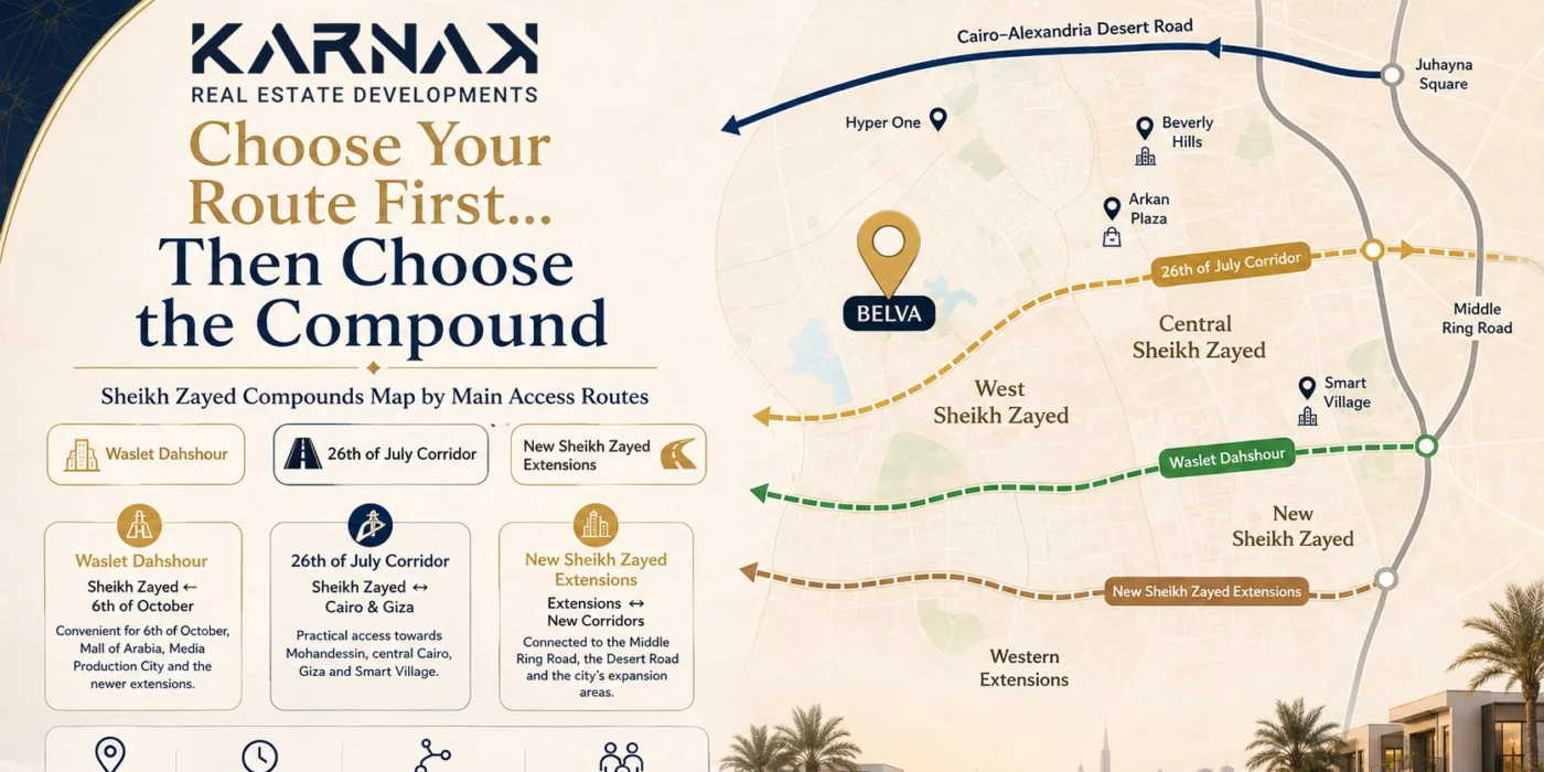
Explore Sheikh Zayed compounds by their main access routes, from Waslet Dahshour and the 26th of July Corridor to the New Sheikh Zayed extensions, with a practical guide to help you choose the location that best fits your daily routine before comparing units and prices.
Sheikh Zayed Compounds Map by Main Access Routes: Waslet Dahshour, 26th of July and New Sheikh Zayed
Choosing a compound in Sheikh Zayed should not begin with the project name alone.
Nor should price be your only starting point.
In many cases, the decision that will have the greatest impact on your everyday life is much simpler:
Which route will you actually use every day?
Do you regularly travel via Waslet Dahshour?
Do you rely on the 26th of July Corridor?
Or is your routine more closely connected to the New Sheikh Zayed extensions, the Middle Ring Road and the Cairo–Alexandria Desert Road?
These questions matter more than they may initially appear. A compound that looks close on a map may be less convenient in practice if it sits away from your usual route to work, schools or everyday services.
This guide therefore approaches the Sheikh Zayed compounds map differently. Rather than ranking developments from best to worst, it groups projects and areas according to the main transport corridors that serve them.
The idea is to identify the route that best fits your routine first, then compare the developments located around it.
Why Read the Sheikh Zayed Map by Access Routes Rather Than Compound Names?
When looking for a home, it is natural to start with familiar names such as Beverly Hills, ZED, Belva or newer developments in West Sheikh Zayed.
But once you actually live there, the project name is not what affects your day-to-day routine.
What matters is:
- The road you take every morning.
- The entrance you usually use.
- Proximity to schools.
- The distance to malls and everyday services.
- How easily you can get home at the end of the day.
- How many alternative routes are available if one road becomes congested.
For this reason, it is useful to think of Sheikh Zayed in terms of three main movement corridors:
Waslet Dahshour
26th of July Corridor
New Sheikh Zayed extensions
This does not mean that every compound depends on one road alone. Some locations can be reached through several routes.
The aim is to identify the route most relevant to everyday life.
Route One: Waslet Dahshour in Sheikh Zayed
Waslet Dahshour is one of the key transport routes in West Cairo, connecting Sheikh Zayed with 6th of October, the Cairo–Alexandria Desert Road and the newer expansion areas west of the city.
For buyers, this makes the road particularly relevant if their daily routine regularly involves:
- 6th of October.
- Juhayna Square.
- Media Production City.
- The areas surrounding Mall of Arabia.
- West Sheikh Zayed.
- The city’s newer expansion areas.
Waslet Dahshour also connects with New Sheikh Zayed, making it one of the most important access routes for developments located west and southwest of the city. (Best Places to Live Near Waslet Dahshour: Why Is Demand Increasing?)
Who Benefits Most From Living Near Waslet Dahshour?
This route can be particularly practical if a large part of your daily routine takes you between Sheikh Zayed and 6th of October.
For example:
If you work in Media Production City or 6th of October, living close to Waslet Dahshour can reduce the need to drive deeper into Sheikh Zayed before heading towards your destination.
Proximity to the route may also suit families whose schools, shopping and other regular services are spread between Sheikh Zayed and 6th of October rather than concentrated entirely in central Sheikh Zayed.
Where Does Belva Fit on This Map?
This is where Belva Compound becomes particularly relevant.
The official project page shows that Belva is:
- Close to Beverly Hills.
- Connected to the Cairo–Alexandria Desert Road.
- Accessible from Waslet Dahshour.
- Located within West Cairo’s expanding residential area.
Karnak Real Estate Developments’ access guide for Belva also explains that Waslet Dahshour can provide a practical route for those travelling from parts of 6th of October, while the 26th of July Corridor remains a key option for those approaching from central Cairo.
This means Belva is not dependent on a single access route.
Residents can approach the development through different connections depending on the direction of their journey.
If Belva is among the developments you are considering, you can read the guide to how to reach Belva Sheikh Zayed for practical routes from Cairo, 6th of October and New Cairo.
Which Services Should You Measure From Your Compound?
When looking at a map of Sheikh Zayed compounds, do not measure only the distance to the nearest main road.
A more useful approach is to choose three or four destinations you visit regularly each week and measure the journey to each one.
For example:
- School
- Club
- Supermarket
- Workplace
- Hospital
- Mall
This is when a general map becomes useful for your own personal decision.
Sheikh Zayed itself offers a well-established network of services, including schools, hospitals, malls and clubs. In some cases, this reduces the need for residents to travel outside the city on a regular basis.
You can also review the guide to types of apartments for sale in Sheikh Zayed to explore some of the schools, malls and services that typically factor into a family’s home-buying decision.
Route Two: The 26th of July Corridor
If your daily routine regularly takes you towards central Cairo or Giza, the 26th of July Corridor becomes one of the most important factors to compare.
The 26th of July Corridor is one of the main roads connecting Sheikh Zayed with the eastern parts of Greater Cairo, and many residents rely on it when entering or leaving the city.
The Sheikh Zayed map also shows that areas such as the First District are close to both the 26th of July Corridor and Hyper One, which directly affects how easily residents can access these parts of the city.
Who Is the 26th of July Corridor Most Suitable For?
This route may be more practical if your work or regular commitments take you towards:
- Mohandessin.
- Dokki.
- Central Cairo.
- Smart Village and the surrounding areas.
- East Sheikh Zayed.
Living close to the corridor may also reduce the amount of time spent navigating internal streets before reaching the main road.
Again, however, do not rely only on the distance measured in kilometres.
What matters is how long it takes to reach the corridor from inside the development itself.
Is Belva Far From the 26th of July Corridor?
Belva should not be assessed as a development connected only to Waslet Dahshour.
Karnak Real Estate Developments’ access guide explains that those travelling from central Cairo can use the 26th of July Corridor, enter Sheikh Zayed towards Hyper One and continue via Al Nozha Street to reach the development.
Another page on the Karnak Real Estate Developments website also identifies Belva as being close to the 26th of July Corridor and the Cairo–Alexandria Desert Road.
This can be particularly relevant for a buyer with a mixed weekly routine:
Central Cairo during the working week, and
6th of October or West Cairo at other times.
Having several possible routes means that the location can be assessed in terms of travel flexibility rather than its connection to a single road.
Compounds and Areas Near the 26th of July Corridor
When you look at Sheikh Zayed from the perspective of the 26th of July Corridor, several different neighbourhoods and residential areas become relevant to the comparison.
For example:
The First District is one of the areas located close to the 26th of July Corridor and includes a range of services and residential developments.
The Sheikh Zayed map also shows that the Eighth District benefits from proximity to the corridor while remaining connected to other roads.
This highlights an important point:
A Sheikh Zayed Compounds Map Should Not Be Just a List of Names
It is far more useful to know:
Which entrance to the city will you actually use?
And then:
How long does it take to get from the development to that entrance?
Route Three: New Sheikh Zayed and the Western Extensions
The third corridor works a little differently.
Here, we are not talking about one road alone, but rather a wider urban expansion network that includes:
- Waslet Dahshour.
- The Middle Ring Road.
- The Cairo–Alexandria Desert Road.
- The northern extensions of 6th of October City.
- Newly developing urban areas across West Cairo.
This is generally the area people are referring to when searching for:
New Sheikh Zayed map, or
New Sheikh Zayed developments.
What Is the Difference Between Established Sheikh Zayed and New Sheikh Zayed From an Access Perspective?
The key distinction is not that one is necessarily “better” than the other.
The difference lies in the way you move around.
Within established Sheikh Zayed, residents rely more heavily on the city’s existing road network and established services.
In the New Sheikh Zayed extensions, accessibility depends more heavily on expansion routes such as the Middle Ring Road, Waslet Dahshour and the Cairo–Alexandria Desert Road.
New Sheikh Zayed may therefore make a great deal of sense for someone who works in West Cairo or frequently uses the ring-road network.
It may be less practical, however, for someone who needs to travel into the heart of Sheikh Zayed or central Cairo every day.
The deciding factor is not the name of the area.
It is:
Your everyday travel pattern.
How Should You Use a New Sheikh Zayed Map?
If you are comparing developments in New Sheikh Zayed, do not begin with the project itself.
Start with these questions:
Where is the development entrance in relation to the Middle Ring Road?
Is there direct access to Waslet Dahshour?
How far is it from the Cairo–Alexandria Desert Road?
Do you need to enter established Sheikh Zayed to reach essential services?
Is the school or club you regularly use in the same direction as your commute, or does it require travelling the opposite way?
You can also read the guide to New Sheikh Zayed developments to explore the main transport routes surrounding the expansion areas.
Decision Table: Which Route Best Fits Your Daily Routine?
| Your Daily Routine | Route Worth Considering First |
| Frequent travel between Sheikh Zayed and 6th of October | Waslet Dahshour |
| Work or regular commitments towards central Cairo and Giza | 26th of July Corridor |
| Travel between newer developments and West Cairo | New Sheikh Zayed extensions |
| Frequent use of the Cairo–Alexandria Desert Road | Developments close to the Desert Road |
| You need several alternative routes | Look for a development connected to more than one main corridor |
This table is not a ranking of developments.
It is simply a starting point for building your own location decision map.
How Should You Measure Distance to Everyday Services?
One common mistake is to read a claim such as:
“5 minutes from a particular mall”
and assume that this tells you everything you need to know.
In reality, travel time varies according to:
- The compound exit you use.
- The time of day.
- The direction of traffic.
- Road diversions.
- The route you take.
Use approximate distance only as an initial reference.
Then test the journey yourself.
For example, if your child attends a particular school, travel from the development to the school during the morning school run.
If you work in Smart Village, test the route during rush hour.
If you travel to 6th of October several times a week, try Waslet Dahshour under the conditions in which you would normally use it.
This real-world test is more valuable than any marketing estimate.
Which Landmarks Can You Use as Reference Points in Sheikh Zayed?
Rather than trying to memorise every road, you can use several well-known landmarks as reference points when comparing locations.
These include:
- Hyper One.
- Beverly Hills.
- Arkan Plaza.
- Mall of Arabia.
- Sheikh Zayed Club.
- International schools.
- The Cairo–Alexandria Desert Road.
For example, the Belva access page uses Hyper One as a clear reference point for travellers arriving from several directions, as the development is located nearby and can be reached via Al Nozha Street.
This is a very practical way to approach any development you are visiting for the first time:
Choose a familiar landmark first, then measure the journey from that landmark to the development.
Do not compare distance alone… compare the number of alternatives
A development that is 10 minutes from one major road is not necessarily more accessible than another that is 12 minutes away but connected to two or three different routes.
When comparing locations on a Sheikh Zayed compounds map, ask:
Is there an alternative route?
If the 26th of July Corridor is congested, can I use the Desert Road?
If I am travelling towards 6th of October, can I use Waslet Dahshour?
If I am heading towards New Sheikh Zayed, is the Middle Ring Road practical?
This kind of flexibility can have a greater impact on everyday convenience than a two-minute difference in advertised travel time.
How Does Belva Perform Across the Three Main Access Routes?
Applying the same approach used throughout this guide, Belva benefits from being located within a road network that allows access from more than one direction.
From central Cairo: the 26th of July Corridor can be used towards Sheikh Zayed, followed by the Hyper One area and Al Nozha Street.
From 6th of October: either the 26th of July Corridor or Waslet Dahshour may be used depending on your starting point.
From the Desert Road and West Cairo: the development is connected to the Cairo–Alexandria Desert Road area, with access towards Waslet Dahshour and Sheikh Zayed’s main routes.
This does not automatically make Belva the “best compound” in Sheikh Zayed.
It does, however, make the development worth comparing if route flexibility is an important part of your buying decision.
If You Are an Investor, Why Does the Road Network Matter?
An investor will not necessarily live in the property they purchase.
But a future buyer or tenant will still consider the location carefully.
The appeal of a development is therefore linked to practical questions such as:
Is commuting to work straightforward?
Are schools nearby?
Is the area connected to major roads?
Are alternative routes available?
Can essential services be reached within the same general travel corridor?
Understanding the map therefore helps investors assess how practical a location may be for future users, rather than relying solely on the project name.
And if you are buying a home to live in?
Owner-occupiers should be even more specific.
Create a small map of your own daily life.
Write down your five most important regular destinations:
- Work.
- Your children’s school.
- Your club.
- Your usual supermarket or mall.
- Your family home or another place you visit every week.
Then compare each development against those destinations.
The development that suits you best may not be the one closest to central Sheikh Zayed.
It may simply be the one that reduces your total weekly travel time.
Roads and entrances can change over time, while development boundaries and construction phases may also expand.
You can begin with the guide to the Sheikh Zayed neighbourhood map to understand the main districts, then use up-to-date navigation maps when visiting developments in person.
Checklist Before Visiting a Compound in Sheikh Zayed
Before arranging your visit, identify the access route that most closely reflects your real daily routine.
Then, during the journey, pay attention to:
- How long it takes to reach the development.
- The route you used.
- How easy it is to reach the entrance.
- Whether an alternative route exists.
- The nearest service point you would actually use.
- The nearest suitable school.
- How easily you can return to the main road.
- Traffic conditions at the same time of day you would normally make the journey.
Only after that should you move on to comparing:
The unit + size + price + payment plan.
Frequently Asked Questions About the Sheikh Zayed Compounds Map
What Are the Main Access Roads to Sheikh Zayed Compounds?
Some of the main routes affecting access within and around Sheikh Zayed include the 26th of July Corridor, Waslet Dahshour and the Cairo–Alexandria Desert Road, as well as the Middle Ring Road for the newer expansion areas.
Why Is Waslet Dahshour Important When Choosing a Home in Sheikh Zayed?
Waslet Dahshour connects Sheikh Zayed with parts of 6th of October, the Cairo–Alexandria Desert Road and New Sheikh Zayed, making it particularly relevant for people who travel frequently between these areas.
Where Are New Sheikh Zayed Developments Located?
The New Sheikh Zayed extensions are connected to several key routes, including Waslet Dahshour, the Middle Ring Road and the Cairo–Alexandria Desert Road, as well as the wider expansion areas west of the city.
Is Belva Close to Waslet Dahshour?
Belva’s official project page indicates that the development can be accessed from Waslet Dahshour. Its location is also close to Beverly Hills and connected with the Cairo–Alexandria Desert Road.
Can You Reach Belva via the 26th of July Corridor?
Yes. The access guide published by Karnak Real Estate Developments explains that travellers approaching from central Cairo or certain parts of 6th of October can use the 26th of July Corridor, then enter the Hyper One area and continue via Al Nozha Street towards the development.
Choose the route first… then choose the development
When looking at a Sheikh Zayed compounds map, do not begin by asking:
Which is the most famous development?
Start with a more useful question:
Which road will I use most often?
If your routine regularly takes you towards 6th of October, start with Waslet Dahshour.
If your work takes you towards Cairo and Giza, test the 26th of July Corridor.
If you are considering the newer expansion areas, examine the network formed by the Middle Ring Road, the Desert Road and Waslet Dahshour.
And if Belva is among your options, try approaching the development using the route you would realistically travel most often, rather than only the fastest route shown at the particular time of your visit.
Choose the access corridor that fits your routine, then arrange a site visit before comparing the unit and price.
You can start with the official Belva page to review the development’s location, or read the guide to the closest compounds in Sheikh Zayed 2026 for a more practical way to compare what “close” really means.
Find the Right Belva Unit for You
Request the latest Belva details and receive an initial recommendation for the unit and payment plan that best suit your requirements.